Thursday, February 9, 2012

Why was there no Delaware Colony?

When peering at the various boundaries throughout the US, there is one that stands out for an odd reason: the Pennsylvania - Delaware boundary. It's almost circular.

How did such a thing come about? When looking at this arc, its center is not at Wilmington, which is the capital of Delaware. It is New Castle, which is located 12 miles from this border. This arc has also been called "The Twelve Mile Circle".  When William Penn received a charter for his new Province of Pennsylvania on February 28. 1681, his new province was:

"bounded on the East by Delaware River, from twelve miles distance Northwards of New Castle Towne unto the three and fortieth degree of Northerne Latitude... The said Lands to extend westwards five degrees in longitude, to bee computed from the said Easterne Bounds".

This boundary by New Castle was described as:
"a Circle drawne at twelve miles distance from New Castle Northward and Westward unto the beginning of the fortieth degree of Northern Latitude"

There was confusion if the the circle was supposed to have a diameter, radius, or circumference of 12 miles around New Castle. In the end, a radius of 12 miles was used. In fact, this extends all around New Castle including the border of New Jersey. In fact, there are parts of land attached to the NJ side of the Delaware River that are technically in Delaware because it falls within 12 miles of New Castle. Most websites and blogs stop there. But where did this 12 mile distance come from?

The area was originally colonized by the Dutch and the Swedes. One of the main forts in the area was in New Castle. Eventually, the British would win control over this region (and the Hudson River valley). Charles II granted all the land west of the Connecticut River to the east side of Delaware Bay to his brother, the Duke of York, in 1664. The region of present day Delaware was outside this. Since, the Duke was given the Dutch claims along the Hudson River, the Duke assumed control over all other Dutch areas on the west bank of the Delaware Bay.  


But if you look further back, this area was given to Lord Baltimore in his Charter of Maryland in 1632. The northern boundary of this new colony was at the 40th degree latitude. The land included all parts west of the Delaware Bay up to the mouth of the Potomac River and up to the headwaters of the Potomac. As shown on the right, this would include present day Delaware. Lord Baltimore tried to claim that his grant included the region that the Dutch had settled. Lead by Augustine Herman, the Dutch countered that Baltimore's claim includes land that had not been settled which was not the case for the west bank of a Delaware Bay. Hence, that region should be excluded. In the end, the two parties decided to divide the peninsula in half but such a line was not marked until Mason and Dixon surveyed it in the 1760s. So there is no mention of 12 miles in this part of the story. 

When William Penn attempted to form a colony in the area, his grant of 1681 mentions the southern boundary to be at the 40th degree latitude. In those days, there was a variation of interpretation for this. Some drew a boundary line at the start of the 40th degree. Others would surveyed a line at the end of the 40th degree. This amount of variability could leave Philadelphia in Maryland or Baltimore City in Pennsylvania. The agents for the Duke of York thought the 40th degree was about 20-30 miles north of New Castle (so outside of this newly acquired region). William Penn and the head of the Privy Council (Lord Chief-Justice North) thought it was about 12 miles north of New Castle. So this is the origin of this particular distance. The supposed southern border of Pennsylvania would approach the west bank of the Delaware and get as close as 12 miles from New Castle. The best outcome would be the 40th degree latitude would meet at the top of this circle. In the end, the 40th degree was too far north and further negotiations would lead to the present day boundaries. 

But there is one more tidbit. In 1682, Penn would received a deed from the Duke of YOrk to "rent out" the "Lower Counties on the Delaware" to provide more access to the Delaware Bay. There was still a dispute between the Duke of York and Lord Calvert (of Maryland) as to who actually controlled this previous Swedish colony. Regardless, the Duke deeded it to Penn on August 24 (or 28), 1682. This claim by Penn was solidified by King James's compromise in Nov 1685 to divide the peninsula in half above the Cape Henlopen line of latitude which placed those Lower counties under the rule of the King (to Duke to Penn).

Eventually, those living in this region would want to have their own government that was not linked to Philadelphia.  This was somewhat granted in 1701 where there would still be a single governor but the local representatives would function independently from Philadelphia. After the Declaration of Independence was signed, these three counties quickly organized into an independent state with the creation of its own constitution in September 1776. Eventually, it would be the first state to ratify the new US Constitution in 1787. So, first state in this new Federal union wasn't even an official British colony.

Thursday, February 2, 2012

Changing when the Seasons Start...

1st Question: When do the seasons began?
2nd Question: Are there different ways to define seasons?
3rd Question: How about a more psychologically appealing seasons?

There are four main dates in the calendar that relate to the environment we live in: the December and June solstices, and the March and September equinoxes. Seasons have been defined by certain periods of time in a year. Seasons usually indicate changes in amount of daylight and the weather. But there are regions of the world where the daylight does not change much during the year but the weather can: e.g. monsoon season or rainy season. But we'll stick with the typical temperate zone seasons of spring, summer, fall, and winter.

Popular media will use those dates to indicate when a season "starts" as in winter starts on December 21 or 22 in the northern hemisphere. But seasons can be defined in different ways.

An astronomical POV could be used where it is the position of the sun in the sky that determines the seasons. In this case, solstices and equinoxes would be the middle of the seasons. For example, the June solstice is the day the sunrises the earliest and should be in the middle of northern hemisphere summer (not the start). Therefore, astronomical seasons start in between a solstice and equinox. Some call these dates cross-quarter days, or days halfway between a solstice and equinox. In the northern hemisphere, this would be on Feb 1 or 2, May 1, Aug 1-2, and Oct 31-Nov 1. This is similar to using the amount of sunlight received (insolation) to determine various quarters of the year.

Another way to look at when the seasons start is based upon the weather (or temperature). When using average temperatures for a particular hemisphere, the starts of the seasons are March 1, June 1, September 1, and December 1. In general, the temperature changes typical for those seasons have not started at these dates (possibly due to so called thermal lag).

So where does that leave us?


SpringSummerFallWinter
Astronomic February 1,2May 1August 1,2October 31,November 1
Meteorologic March 1June 1September 1November 1
Popular Media March 20,21June 20,21September 22,23December 21,22

Can we improve upon these definitions?

Why not take the sunlight approach but disregard the need to have seasons with similar number of days. Using Chicago as an example, below is a graph of the sunrise and sunset times:
The amount of daylight varies from 9:08 to 15:14 throughout the year. We can divide the amount of possible daylight per day into 4 equal durations:
  • 9:08 to 10:39:30
  • 10:39:30 to 12:11
  • 12:11 to 13:42:30
  • 13:42:30 to 15:14
There will be 2   periods of the year where each of these durations would occur. Therefore, we could define winter as the 2 sections with the least daylight while summer would be the 2 sections with the most daylight. Spring and Fall would occur in between. If we do that, what do the seasons look like?

So spring is from February 16 to April 22. Summer goes until August 18. Fall ends at October 24. Winter continues through February 16. 
  • Spring: February 16 to April 22
  • Summer: April 23 to August 18
  • Fall: August 19 to October 24
  • Winter: October 25 to February 15
The solstices and equinoxes are in the middle of their respective seasons. But the length of each season is different: Summer and winter are about 16 1/2 weeks each. Spring and fall are about 9 1/2 weeks each. 

But there is another way to define a season: using the sunset (or sunrise). Excluding daylight savings, sunset varies from 16:19 to 19:30. Like the hours of daylight, you can divide that up into quarters and assign seasons based upon what range of sunset times occur.  


Using that idea, spring would start on February 2. Summer starts on April 24. Fall starts on August 20. And winter begins on October 16. 
  • Spring: February 2 to April 23
  • Summer: April 24 to August 19
  • Fall: August 20 to October 15
  • Winter: October 16 to February 1

But if you add daylight savings and assume the latest sunset is at 20:30, things are little more interesting. Spring would start on February 9. Summer begins on April 11. Fall starts on August 30. And winter begins on November 4. So where does that leave us?


SpringSummerFallWinter
Astronomic February 1,2May 1August 1,2October 31,November 1
Meteorologic March 1June 1September 1November 1
Popular Media March 20,21June 20,21September 22,23December 21,22
Daylight Duration February 16April 22,23August 18October 24,25
Sunset February 2April 24August 20October 16
Sunset w/ Daylight Savings February 9,10April 11August 30November 4

Anyway, that's just me. So what do we use? The best combination of seasons would be the one with long summers, not as long winters, and spring happening earlier. And using the sunset times with daylight savings fits those requirements: Spring starts 6 weeks early. Summer is 20 weeks long. Winter starts earlier but only lasts 14 weeks. Maybe this should be called the socioeconomic seasons? Just a thought.

Wednesday, January 25, 2012

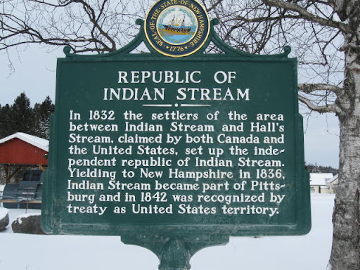
Which way to the Republic of Indian Stream?

Marking boundaries was not a big deal in the early history of the US. Typical these boundaries were in the uninhabited frontier. After the Revolutionary War, a boundary between the US and British North America (Canada) was defined in the "Article 2nd" of theTreaty of Paris 1783. For the region of Maine to New York, the international boundary would start:

"along the said Highlands which divide those Rivers that empty themselves into the river St. Lawrence, from those which fall into the Atlantic Ocean, to the northwesternmost Head of Connecticut River; Thence down along the middle of that River to the forty-fifth Degree of North Latitude; From thence by a Line due West on said Latitude"


An early map of New Hampshire from 1799 is on the right. Zooming to the area in question on the left.


But a little question arose between the two countries: where is the northwestern most head of the Connecticut River?
Great Britain had the boundary going through the Connecticut Lakes (starting at the Third and Fourth Lake). Not surprisingly, the US thought the northwestern most head water was at the start of Halls Stream. Therefore, there was an overlap of land claims, shown in green in the above map. Both countries apparently sent tax collectors to the settlers there. Also the British tried to enlist them into the British military and to tax them for importing goods. 

On April 6, 1829, the citizens in the area declared their independence from Great Britain and the United States and named their new country, the Indian Stream Republic. They created a government, constitution, and bill of rights. This was done in the main town in the region, Pittsburg. Also a 40 person militia was created to protect the settlers. Several small skirmishes occurred over the next 7 years. Many of these were arrests of pro- or anti-Canadian residents either in Canada or the Indian Stream Republic. One main incident occurred in 1835 when a settler was arrested in Canada for an unpaid hardware store debt. Other settlers went to Canada and shot up the house of the judge in charge of that case. To help further quell any antagonism between the two countries by these settlers, the New Hampshire militia invaded the region. The Republic voted to be annexed by the US in 1835. Negotiations between the two countries resulted in Great Britain giving up its claim to the land in January 1836. The US then annexed the area in May 1836. It was made official in the Webster-Ashburton Treaty (November 10 1842) where this northern boundary starts:

"down along the said highlands which divide the waters which empty themselves into the river Saint Lawrence from those which fall into the Atlantic Ocean, to the head of Hall's Stream; thence, down the middle of said Stream, till the line thus run intersects the old line of boundary surveyed and marked by Valentine and Collins previously to the year 1774, as the 45th degree of north latitude,"

The independent Republic of Indian Stream only lasted from 1832 to 1836. It  wasn't the first of the breakaway republics since the US was founded (that was probably the Independent Republic of West Florida), but it was one of the longer lasting ones because of a valid disagreement in an international treaty.

But the oddities do not end there. In 1836, that main town, Pittsburg, ended up annexing all of the land that was part of the Republic of Indian Stream. In doing so, the town now covered 291 square miles, the largest town in America, and it still is.

Tuesday, January 17, 2012

Does Illinois share a border with Michigan (AKA who owns the Great Lakes)?

1st Question: What are the borders of the Great Lakes states?
2nd Question: Why were the borders drawn up like that?
3rd Question: Who owns the Great Lakes?

Most of us learned memorized the location of all fifty US states some time in grade school. Some of us were even able to recognize or draw the shape of the all the US states. But something odd happens to the shape of states around the Great Lake. I'll use Illinois and Indiana as an example.

Now 5 states were formed from the old Northwest Territory, a region north of the Ohio River and east of the Mississippi: Ohio, Michigan, Wisconsin, Illinois, and Indiana. (Parts of it did become Minnesota.) The guidelines for how the states should be created from the NW Territory is contained in the Northwest Ordinance of 1787. One part of this ordinance states the region could be divided into northern and southern states by a boundary

"which lies north of an east and west line drawn through the southerly bend or extreme of Lake Michigan"


If those words were followed precisely, then the states of Illinois and Indiana would look like the graphic on the right. Chicago would have ended up in Wisconsin and the shapes of those 2 states would obviously be different.

So how did these states end up with different borders? There are well known stories about how the northern borders got extended further north than the southerly end of Lake Michigan.

Indiana supposedly wanted more usable lakeshore. Using the original guidelines, they would not have any access to Lake Michigan. So the state extended the border 10 miles north when its boundaries are described in its state constitution. Congress followed suit on June 23, 1836 when they agreed to this 10 mile northerly deviation. But what about Illinois?

The change in the Illinois northerly boundary is attributed to Nathaniel Pope, the states first (territorial) delegate to the US Congress. While Congress was debating the Act to admit Illinois as a state into the Union, Pope suggested that the northern boundary be moved from the southernly end of Lake Michigan to a parallel at 42 degree 30 minutes.

Various reasons were given to move the boundary. Politicians then were already concerned of a potential rift in the Union between Northern and Southern states. Pope may have argued that isolating Illinois from Lake Michigan would force the state to use the Mississippi and Ohio Rivers for commerce which would make it dependent on Southern States. By having access to Lake Michigan, it could form relationships with other northerly states such as New York or Pennsylvania. The Annals of Congress (April 4, 1818) describe Pope arguing that giving Illinois access to Lake Michigan would connect it to northern states and "would afford additional security to the perpetuity of the Union". He also argued that the new northern border would include Fort Dearborn (being rebuilt) at the Chicago River in the newly created state and increase the interest of creating a canal between Lake Michigan and the Mississippi River next to Chicago. Congress agreed to the changed boundary.

So who owns the Great Lakes? Well, regional maps rarely show the boundaries of the states as they extend into the Great Lakes such as the northern boundaries of Illinois and Indiana which actually extend into Lake Michigan. These added area of Lake Michigan can be included in the representations of the states to better understand how the Great Lake states related to each other.

So the shapes of the Great Lake states go from this:

to this:

But I doubt anyone will learn them this way. Most lakes that cross a state boundary are not big enough to cause a significant change in the boundary of states (exception being Lake Tahoe). The Great Lakes are the exception. States extend into them. So if you're drawing the state of Illinois, don't forget the piece the sticks out north and east of Chicago. Besides Ohio, Indiana and Wisconsin, Illinois also borders Michigan. It just happens in the middle of Lake Michigan.

Saturday, September 25, 2010

Introduction...

"Exploring the past is about understanding the future..."


This blog will be a place to record commentaries, musings, and explorations locally and distantly about various historical and geographic items and events. But not just any item. 


Most will be solutions to satisfy a curiosity implanted in my memories. Others will be recalling and trying to experience historical events. But all will be fun, I hope.


Photo to the right:
Monument to the Great Chicago Fire of 1871 - It is placed at the site of Catherine O'Leary's barn where the great fire supposedly started. The story of her cow knocking over a lantern is a myth. The fire spread east and north (direction of the Sears Tower) and eventually burned down about 1/3 of the city. The photo shows two extremes of the Chicago's history - the start of the fire that destroyed much of it and the tallest building in the rebuild area. 


(NE corner of Dekoven Street and Jefferson Street)