
"along the said Highlands which divide those Rivers that empty themselves into the river St. Lawrence, from those which fall into the Atlantic Ocean, to the northwesternmost Head of Connecticut River; Thence down along the middle of that River to the forty-fifth Degree of North Latitude; From thence by a Line due West on said Latitude"

An early map of New Hampshire from 1799 is on the right. Zooming to the area in question on the left.
But a little question arose between the two countries: where is the northwestern most head of the Connecticut River?

Great Britain had the boundary going through the Connecticut Lakes (starting at the Third and Fourth Lake). Not surprisingly, the US thought the northwestern most head water was at the start of Halls Stream. Therefore, there was an overlap of land claims, shown in green in the above map. Both countries apparently sent tax collectors to the settlers there. Also the British tried to enlist them into the British military and to tax them for importing goods.
On April 6, 1829, the citizens in the area declared their independence from Great Britain and the United States and named their new country, the Indian Stream Republic. They created a government, constitution, and bill of rights. This was done in the main town in the region, Pittsburg. Also a 40 person militia was created to protect the settlers. Several small skirmishes occurred over the next 7 years. Many of these were arrests of pro- or anti-Canadian residents either in Canada or the Indian Stream Republic. One main incident occurred in 1835 when a settler was arrested in Canada for an unpaid hardware store debt. Other settlers went to Canada and shot up the house of the judge in charge of that case. To help further quell any antagonism between the two countries by these settlers, the New Hampshire militia invaded the region. The Republic voted to be annexed by the US in 1835. Negotiations between the two countries resulted in Great Britain giving up its claim to the land in January 1836. The US then annexed the area in May 1836. It was made official in the Webster-Ashburton Treaty (November 10 1842) where this northern boundary starts:
"down along the said highlands which divide the waters which empty themselves into the river Saint Lawrence from those which fall into the Atlantic Ocean, to the head of Hall's Stream; thence, down the middle of said Stream, till the line thus run intersects the old line of boundary surveyed and marked by Valentine and Collins previously to the year 1774, as the 45th degree of north latitude,"
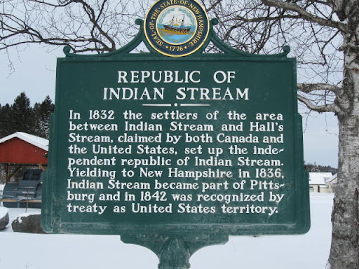 The independent Republic of Indian Stream only lasted from 1832 to 1836. It wasn't the first of the breakaway republics since the US was founded (that was probably the Independent Republic of West Florida), but it was one of the longer lasting ones because of a valid disagreement in an international treaty.
But the oddities do not end there. In 1836, that main town, Pittsburg, ended up annexing all of the land that was part of the Republic of Indian Stream. In doing so, the town now covered 291 square miles, the largest town in America, and it still is.
No comments:
Post a Comment